
Tell Arad
There are two ancient sites at Tell Arad, separated by 1500 years of nothing. The first was a city that thrived from 3000 until 2650 BC. The second was an Israelite fortress, including a temple with a sacrificial altar of exactly the size prescribed in the Book of Exodus. Given the near-desert conditions (about 7 inches of annual rainfall, though slightly more 5000 years ago), we look for an explanation: why would people choose to live here? The answer, for each site, is different, but in both cases constant geographical features played a major role:
The land here forms a bowl, about 25 acres in area, dipping down to a depression where the rock is waterproof, so that rainwater gathers there and stays.
The site occupies the eastern edge of a basin (geographers call it the "Beersheba depression") that stretches in an east-west direction, dividing the Judean mountains to the north from those of the Negev Desert in the south.

The Early Bronze City (3000 - 2650 BC)
The Beersheba "depression" or "basin" makes for relatively easy travel from Arad (1) westward to the trunk road leading to Egypt and (2) eastward to the Dead Sea (one kilometer down). In addition, the only good road through the central mountain range splits in two at Hebron, one branch descending to Beersheba, the other to Arad. At Beersheba, however, there was no city in the Early Bronze Age (EB). With the rare exception of Jericho, we stand at the beginning of urbanization in the land. "Arad" (we don't know its name in this period) lorded it alone in the basin as an urban emporium, exchanging copper from Sinai for the wine, olive oil and grain of the north. Much of the pottery attests to Arad's connections with Egypt and the copper-producing settlements in Sinai. In the north Arad could connect to city states such as Ai, Jericho, Yarmuth, Gezer, Megiddo, Beth Shean, Hazor and Dan.
In addition to wine and olive oil, Egypt wanted asphalt for waterproofing ships and mummification, and asphalt could be had in the Dead Sea. When the earth trembled in the southern part of that deep rift, pieces of bitumen (asphalt) would break away and float to the surface. Presumably, the "Aradians" exported it to Egypt. They deposited chunks of bitumen under the floor of one of their temples - as an offering perhaps.
At the time of the earliest city here, urbanization was well underway on the Upper Euphrates, under Sumerian influence, and Egypt had just entered its first historical period. (One pottery shard at Arad is incised with the name of Narmer, first pharaoh of the first dynasty, who reigned around 3100 BC.) It was a time of population growth. On the basis of archeological surveys, the number of people in the land at this time has been estimated at 150,000 (Mazar p.112). Such growth was spurred by the domestication of livestock, which made possible a more intensive agriculture.
At Arad, for example, archaeologists found the bones of sheep and goats all over the site. There were cattle bones too, indicating use of the plow. The bones of asses testified to the main means of long-range transport. (The horse and camel were not yet domesticated.) Under Ruth Amiran, the Arad archaeologists also found carbonized wheat, barley, peas, lentils, chickpeas, flax seeds and olive pits (visible today in the Early Bronze room of the Israel Museum). Here was a thriving city center, surrounded (a survey has indicated) by villages.
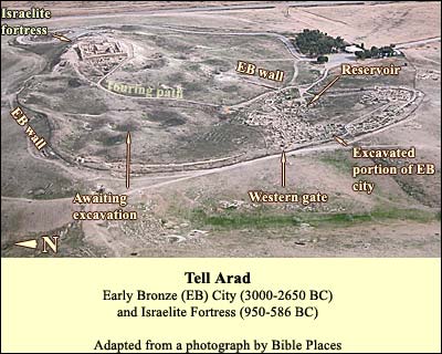
About 2850 BC, the inhabitants built a wall along the watershed of the natural amphitheater. They laid out a network of streets in such a way that all rain falling within the wall would flow downhill to the reservoir, then an open pool of about 1000 square meters. Near it they erected public buildings. The planning was meticulous, as it would have had to be to maintain 2500 people (figuring 100 per acre) despite occasional years of drought and attacks by nomadic tribes. Except for the Israelite fortress, no one ever built here again. Nor has rainfall-erosion taken the toll it has elsewhere. The ruins, therefore, are in a good state of preservation.

Here is another view, from the north and closer in. Note again the city wall running along the watershed, and how the radial pattern would enable water to flow through the streets to the reservoir. More than a kilometer long, the wall would have required a great many soldiers to defend it; no doubt the villagers took refuge in the city and provided troops as well. The wall was probably at least 12 feet high. Its two courses were filled with rubble. From it protruded 35 - 40 towers, which enabled the defenders to shoot at attackers who might try to take cover up against it. These attackers were probably desert tribes such as the later Amalekites, although there may have been occasional problems with Egypt too. The diggers found ash from a major destruction around 2800 BC. The city was then rebuilt.
In addition to the pottery, the city's architecture illustrates its contacts with north and south. Its twin temples were similar in design to those at Megiddo in the north, also from this period. Yet the houses were very like contemporaneous dwellings found in southern Sinai.

Looking into these houses, we can get a feel of what life was like almost 5000 years ago. They all have a similar form (again, central planning at work): from an outer courtyard, where most of the daily chores took place, you took a single step down into the main room, which was rectangular with benches on the sides.
On the benches were vessels. In the middle of the room was a wooden pillar on a stone base. This pillar supported a beam that ran the length of the roof; the roofing material could span the space between each long wall and the beam. The archaeologists even found a clay model of such a house. It shows a runnel around the door, which would have directed the rain away from the opening into the street; thence it would have flowed to the reservoir. Houses of a similar plan have been found in the copper-producing EB settlements of southern Sinai, whose granite shows up in pottery shards found in Arad (as Arad pottery shows up there).
We are not sure what led to the city's final destruction. One or several factors may have had a part. The climate became drier in the middle of the third millennium BC. Also, Egypt became more active in southern Sinai at this time, perhaps undermining Arad's exclusivity as a trade emporium. And of course there were the ever-hungry desert nomads.
Logistics:
Throughout the Negev, don't leave valuables in the bus or car! Arad is a national park.
No telephone.
Nature Reserves and National Parks (Main office: 02/500-5444)
Opening hours:
April 1 through September 30, from 8.00 - 17.00. (Entrance until 16.00)*
October 1 through March 31, from 8.00 - 16.00. (Entrance until 15.00)*
On Fridays and the eves of Jewish holidays, the sites close one hour earlier. For example, on a Friday in March one must enter by 14.00 and leave by 15.00.
One needs a hat, good walking shoes, and plenty of water.